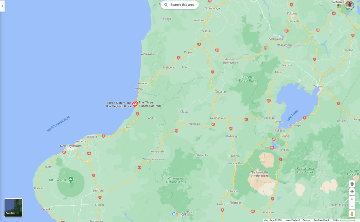
Driving south from Otorohanga down the west coast, the road enters the Awakino Gorge. The road twists and turns beside the river and is a pleasant drive. This part of the country is steep and bush clad sheep and cattle country. Cellphone reception is sparse. You will see a number of seaside villages along the way until you head back inland and up Mt Messenger. This is a steep winding road with a tunnel near the summit. It only takes a few quick minutes (5 to 10) to work your way up and over, but it can seem longer.
We stopped at a very small seaside village with a sign that says “Three Sisters”. On the map, the township is called Tongaporutu .I have lost count of the number of times I have driven past this place without even knowing it was there. It was perfect timing as well.
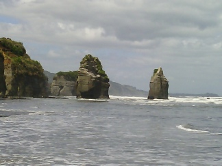
The Three Sisters, Northern Taranaki
The turn into the cark park is quite tricky from the Northern side, just indicate early, slow down and be careful. The road in narrows to one lane and you can’t see much around the bends, but it is quite suitable for all vehicles, even those towing large caravans. At the car park some 300 meters in, there is plenty of parking space and easy turning. Just hope that when you enter or exit that nothing larger than you appears as one of you is going to have to backup. There are number of holiday baches located beside the river and the road.
Timing is crucial, as you want a low tide to be able to easily walk out to the beach to see the “sisters”. Walk along the river out to the sea. Along the way you will see some amazing rock formations and caves. The rocks and track can be very slippery so walk carefully. It takes about 10 minutes to walk out to the seashore, but it is so worth it. The view of the ocean and the “sisters” are truly awesome. You can walk through the many tunnels and marvel at the way sea and land collide. The “sisters” are three rock towers left behind in the sea from erosion. They stand tall and proud. The black sand is stunningly beautiful.
There are no places to camp here.
We stopped for the night at Onaero Camp Ground. Something a little different. Nice big camp sites but rules are very strict, so behave! The toilet and shower facilities are old and insufficient for the size of the camp. The view from beach is great. On the horizon you can see an oil rig and watch the mighty ocean crash against the tall cliffs. Great place to swim and surf cast. The bay is quite small and it is a 1-2 meter drop off to the beach. The locals are very friendly. Not much here in the way of supplies but it is not that far, less than 10 kilometres to Waitara township.
We drove on from here to New Plymouth approx 40 minutes drive. We headed down by the water front at the western side of the city. There is plenty of parking and it is close to the museum and city mall. The view from the pathway next to the sea is spectacular and you can walk, run or bike along the path. The cycle ways around New Plymouth are well worth exploring.
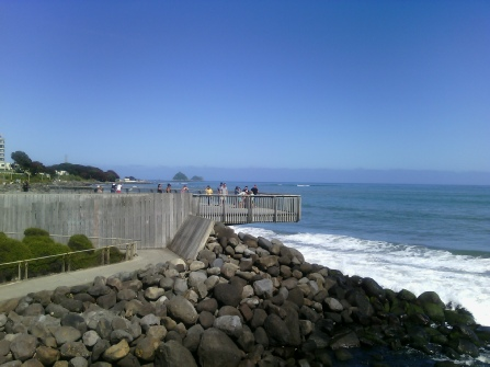
New Plymouth seaside lookout, right over the road from the main shopping district.
Next stop was Stratford. Just West of the Main Street on the Whanganui side of town is the Park. There are some picnic tables under the trees beside the rest rooms and a river walk.
A day trip along the Forgotten Highway State Highway 43 from Statford to Taumaranui was decided on. I have heard a number of stories about this road so it was time to check it out for ourselves. The road starts off wide and well paved but as you get further along it gradually narrows and becomes quite lumpy. Road slumps are common and you pass over two saddles before you reach Whangamonoma one of New Zealand’s iconic pubs and towns. There is a ton of history related to the building of the road and railway line.
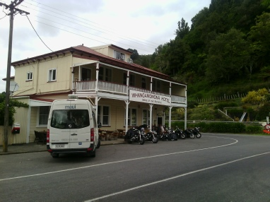
A very popular stopping point on the Forgotten Highway
The pub is a lot like the Black Ball Hilton on the West Coast of the South Island. Old, quaint and full of memories and historic information. Whangamonoma has set itself up as an unauthorised Republic and you can actually get your passport stamped in the pub. There are an excellent selection of meals and drinks available at very reasonable prices and you are made to feel very welcome. You can purchase t-shirts, hoodies, jackets, calendars and other souvenirs to remind you of your time there. There is accommodation available in the pub and also a camp ground for camper vans, caravans and tents.
Further along the road towards Taumaranui is a B & B and Pop over for motor homes. Due to a number of slips on the road and narrow one lane bridges and the quality of the road I do NOT recommend large vehicles attempt this road. It could be done with good towing vehicles but the road is quite rough in places and has some hair raising bends with steep grades.
The views of the steep sheep farm land are great and the road trip is definitely one every tourist and Kiwi should do if they enjoy long country drives. In summer travel early in the morning or later in the afternoon as the hot weather melts the tar seal. The road is very popular with motorcyclists so be prepared to be overtaken often. If you are starting out from the Stratford end you can travel onto Taupo, Turangi, National Park etc. If you are travelling from Taumaranui you can stop in Stratford or travel onto Hawera, New Plymouth, or North towards Hamilton, Auckland, Rotorua etc.
Along the route are a number of notice boards with historic information and places to visit, like tunnels and lookout points. These are not clearly marked until you are right on them and there is very limited safe parking spaces, especially for large vehicles.
The road is mostly sealed. Approx 22 kilometres towards Taumaranui from Whangamonoma is an unsealed section of about 12 kilometres. It is reasonably flat and the road condition varies on how long since it was last graded. There are a couple of bridges in the unsealed sections which are sealed either side, but don’t get excited that the seal has begun again as it hasn’t.
Near the top of one of the saddles is a very unique one lane tunnel. There is a small parking area on the Taumaranui side where you can stop and take photos.
The whole highway is approx 148 kilometres long with no petrol stops. Whangamonoma is 60 kilometres from Stratford and is a great halfway point to take a break.
New Plymouth is a very interesting place. There are a number of places to visit and explore. Over Christmas and New Year there is the Festival of Lights in Pukekura Park. The park is located quite close to the city centre and is well signposted. It features walks through tree lined gardens and has a lake where you can go paddling in small boats. There are a number of different entry ways and exits. The lights festival is quite spectacular but many cities have better displays in my opinion. (Nelson) for example.
The best time to view the lights is from 8.30pm. Parking can be an issue.
There is also the sea wall or shoreline walk which stretches approx 9.5 kilometres long. It is avert pleasant and easy walk but it does crisscross the railway line a few times. You can start anywhere along the route. At times there are seals on the pathway.
There is a tall wind wand opposite the city mall. Along the road a few hundred meters is the city museum. This is a fascinating place, modern and very interactive. There is a cafe/restaurant attached.
Heading south from Stratford are a number of small towns well worth visiting. We stopped in Eltham and found a number of antique and second hand shops, especially down the side streets. The public toilets are cute, clean and tidy. You will find them just behind the library.