The Waikato region is one of the countries largest stretching from just South of Auckland, right down to Taupo, and coast to coast from Coromandel to the West Coast. There are a huge variety of attractions, including bush tracks, surf beaches, rivers, mountains, tunnels, cycle trails, caves, Hobbiton and just too many others to cover.

Hamilton is the countries third biggest city and is the hub for the very rich and productive dairy lands which spread out in all directions. This large city has everything on offer, from river cruises to museums, a zoo, riverside trails, shopping and a very large industrial industry.
The cycle trail that runs along the riverside is awesome and enjoyable for all levels. Just beware that it is two way and very popular with walkers as well as runners and cyclists.
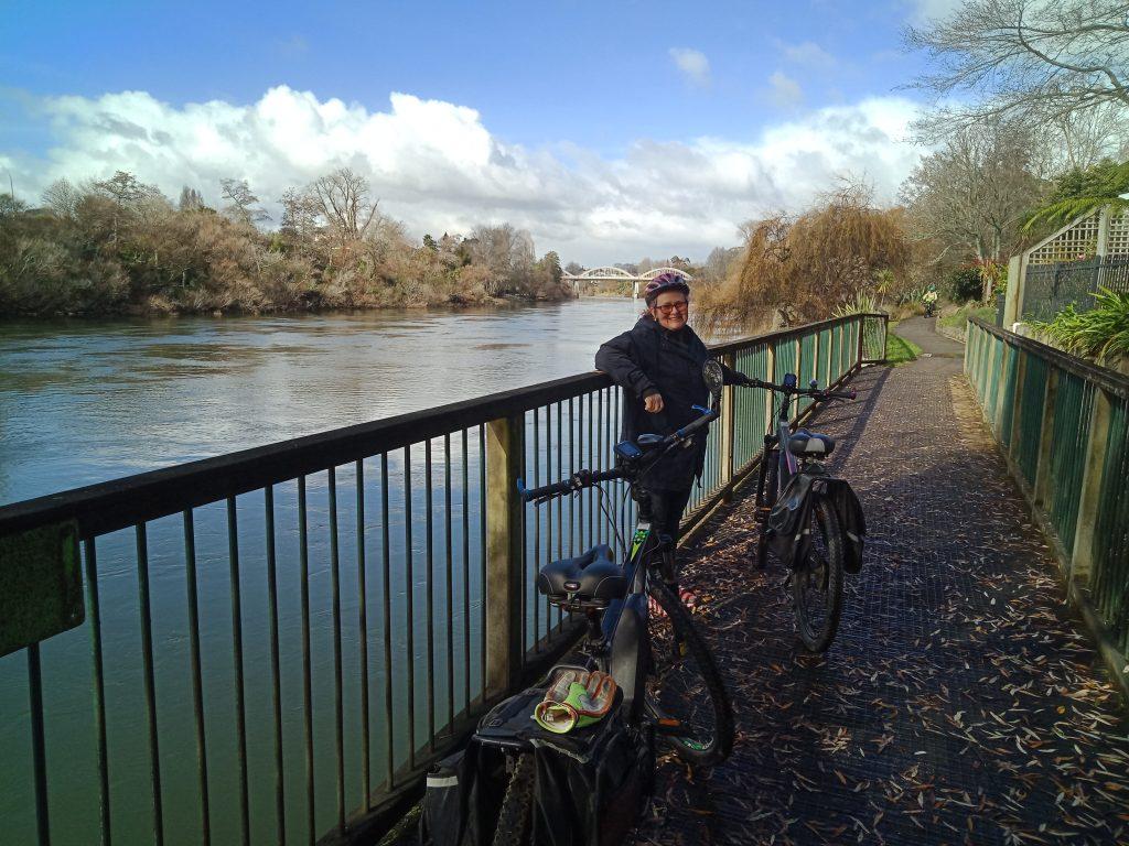
Part of the amazing Hamilton City river trail
I have never been to the mouth of the Waikato River, Port Waikato so as it is very close to Hunua we decided to go and take a look. I phoned ahead to the holiday park and booked a site. Considering that this is the peak of the holiday season I assumed the camp ground would be almost fully booked, but on arriving I was amazed at the available number of sites. What a fabulous place to stay. The facilities are the best I have ever seen as far as cleanliness goes. Ablution blocks are old but immaculate. It is approx one kilometer to the main sunset beach and surf lifesaving club. The Coast is wild west coast and the scenery is spectacular. The river mouth and estuary is only three hundred meters in the opposite direction.
Watch out for the quad bikers as they are everywhere. Also this appears to be the approach or departure from Auckland airport and high overhead jet planes can be heard often. This is a place to stay and explore.
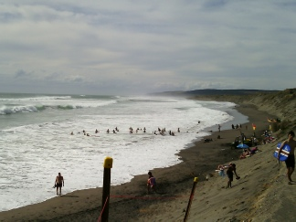
The wild surf at Port Waikato
Sunset Beach Port Waikato
Leaving Port Waikato I wanted to travel the back road and not State Highway One. The road is great, three times longer than the main highway as we were towing the caravan. There are plenty of ups and downs but nothing compared to the East Coast. There are some great views as the road climbs up quite high. It is a well maintained road and suitable for all vehicles, even those towing larger caravans. I look forward to a motorbike road along this road. It is known as State Highway 22. As you exit Port Waikato and reach the “T” intersection, instead of turning left and back over the bridge to Tuakau, turn right and follow the signs to Waignaro Hot Springs. It is like driving along the ridge tops, with great views and a very lightly travelled road meaning no hold ups.
South of Port Waikato there are a number of harbours hosting quaint seaside villages that have plenty to offer. Raglan is one of the larger settlements and is very popular with surfers and artists. The large harbour is very inviting for fishing, water skiing and surfers just outside the harbour. Freedom camping is strictly forbidden so you need to book holiday accommodation in one of the many holiday homes, motels or campground. It is the “wild west coast”, so can get very windy with winds coming ashore from the Tasman Sea.
One of the most visited attractions are the Bridal Veil Falls which spectacular and has easy access via a level wide gravel path to the top lookout and then down some 261 steps to the bottom. For the fit and healthy it is well worth the effort to climb to the base of the falls.
There is a very interesting drive heading south from Raglan towards Kawhia the next village southwards. The road is mostly gravel and narrow, but promises amazing views and beaches to explore. Here’s a few video clips of what you can expect to see.
A very popular surf and fishing beach on the west coast of the North Island approx 20 klm’s south of Raglan accessed via a narrow unsealed road.
Kawhia is a small harbourside village which can be reached via a long sealed road or a much shorter but unsealed road. Both take a round the same travelling time and both offer some amazing scenery. Kawhia has a general store and cafe, boat trips around the harbour, a campground, a number of holiday homes and a very small number of permanent residents. For those that love to visit the Coromandel’s Hot Water Beach, you can avoid the crowds and head to Kawhia’s.
New years eve we wanted to stay at Waignaro Hot Springs but they were closed so we thought about Hamilton where we could catch up with some old friends. On checking Trip Advisor there is only one caravan park and the ratings were terrible so we thought maybe Waitomo Caves. They had one powered site left but at nearly twice the price of other places we decided to try Otorohanga instead. The camp site is located on the Hamilton side of the town. It is quiet, spacious and well maintained. However the railway line is just 100 meters away so we’ll see how night noises go tonight. (Update, there’s a few trains that rattle through at night, but I do love the sounds of trains as long as they don’t blast their horns) New Year’s Day dawned bright and clear after a night of quiet rain. There were three trains in the night and not too loud thankfully.
We priced the cave tours with the cheapest at $49 each. Been there and done that so time to move on as we plan to travel the Forgotten Highway and the electric rail car rides found there.
Our next stop was to be somewhere on the West Coast, but not sure exactly where. There are a number of quaint little towns towards New Plymouth. We stopped for coffee, food and fuel at Tekuiti. This town has a supermarket, fuel, even a Warehouse and large discount department store.
The road is great, wide and well maintained with plenty of passing lanes, although the hill leaving Te Kuiti is a good long steep one.
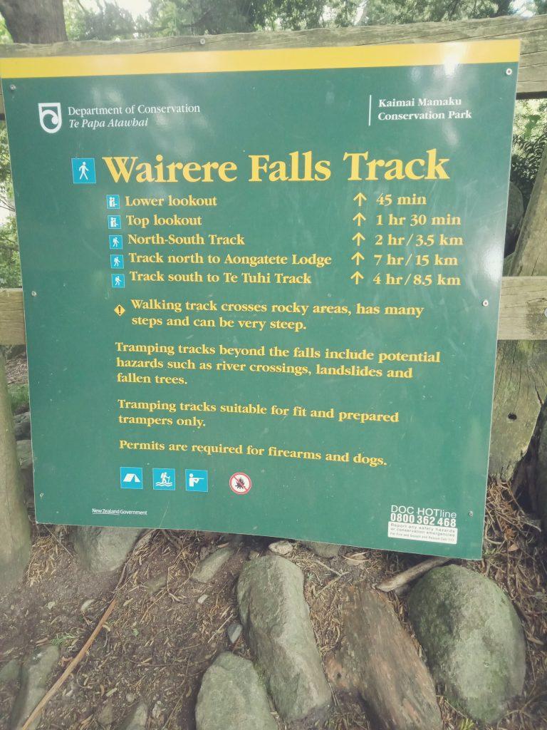
At the base of the Kaimai ranges south of TeAroha is a great, but steep bush walk to view the Wairere Falls. This is accessed from Old TeAroha Road and has a huge sealed carpark suitable for the largest of vehicles. You will see from the photos below that the track is very steep but the views are amazing. You can reach the lookout near the base of the falls in around 45 minutes to over an hour depending on your fitness and speed. The track is well formed, but rugged in places.
Take strong shoes, some snacks and plenty to drink. There are toilets available at the start of the track.

Exiting the Waikato region is in a number of directions. North to Auckland, South to Hawkes Bay and the Central Plateau, East to the Bay of Plenty or West to Taranaki.
The Eastern Route will take you up and over the Kaimai Ranges to the Bay of Plenty. This road is very busy with travellers coming and going between the two districts and the Port at Tauranga. The road is mostly just two lanes with passing lanes at strategic points. Here is a video of the road leaving from Tauriko on the north western side of Tauranga to Matamata, the first large town on the Waikato side and base for Hobbiton.
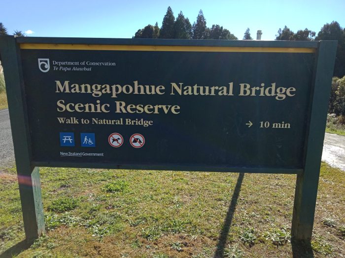
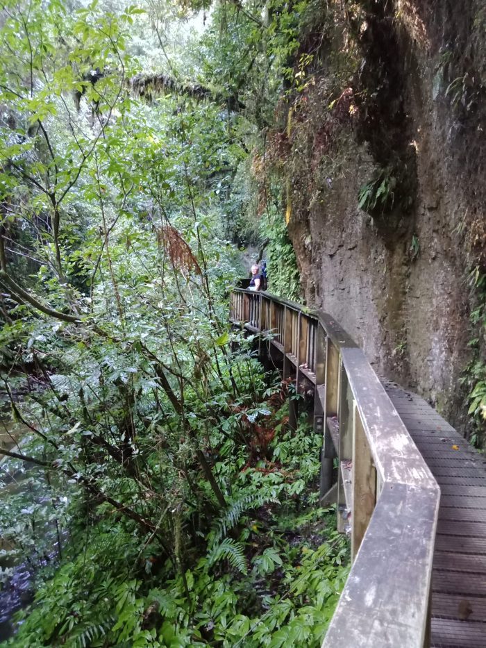
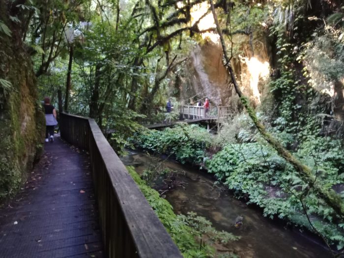
One tourist spot in south western Waikato is the network of Waitomo Caves, but little known is Natural Bridge which is 26 klm’s inland past the caves. The road is twisty and narrow, but sealed and the carpark is suitable for all vehicles, but could become full and caravaners may find it difficult to park or even turn around! It is is a short level walk into the Bridge viewing area where you can walk right underneath the earthen and rock “bridge”. The walkway is well constructed with a short swing bridge. Although the track continues on past the bridge and loops back, it does go through farmland, but honestly, there’s very little to see and definitely not recommended without gumboots! The loop track brings you back out at the start of the track. Here are some pictures of this place.
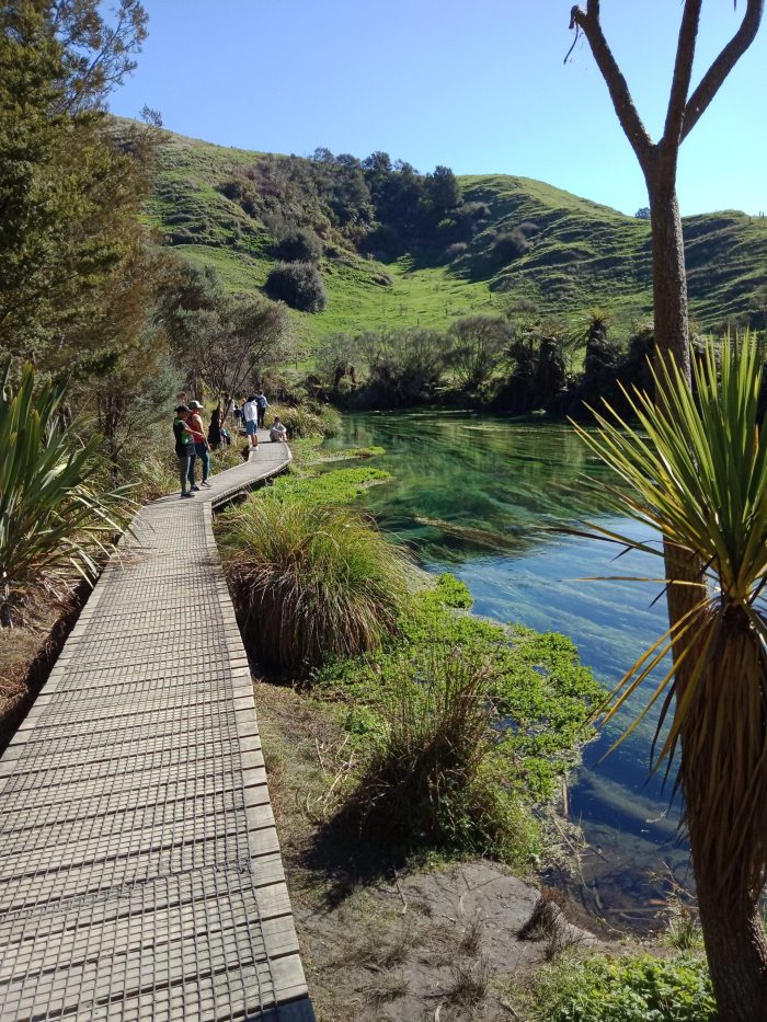
Just over the Kaimai’s from Tauranga and in central eastern Waikato are the Blue Water Springs and Okoriere Hot Pools. The Blue Water springs can be accessed via either the main highway or Leslie Road. The main highway entrance involves a 90 minute walk and the Leslie Road entrance is a 15 minute walk. The Blue Water Springs allow crystal clear water to flow down stream and is a pure natural phenomenon as most of our rivers are brown and murky. The track into the river walk way is mostly level. You do not get to see the springs themselves, just the view of the river, but it is well worth it.