The West Coast of the South Island is an immense region and deserves much more than a quick visit. From the bush clad mountain ranges and stunning rivers in the north, to the glaciers in the south and everything in between, there is a vast variety of things to do and see. Many new Zealanders complain about West Coast weather, but I have never experienced a bad weather day there, sure, they have them but where doesn’t!
You can enter the region from a number of directions. I recommend starting in the north and working your way down with a few side trips into the middle.
After you have visited the “Top of the South” you can drive down through Murchison, then to Westport and north to Karamea.
The journey will take about 3 hours minimum in normal driving conditions, longer if you take time to stop and play along the way. Leaving Nelson you travel over the Hope Saddle as you head south towards Murchison. This is the most twisting and steepest section of road, but still quite suitable for all vehicle types and sizes. Be extra careful in winter as ice can cause major hazards.
Murchison has fuel, food, accommodation, museums and much more. There is a local Police Station as well.
Approx 11 klm’s south you take a hard right over the Buller River and a sharp left at the end of the bridge to head through the Buller Gorge. The gorge has some interesting places to visit. New Zealand’s longest swing bridge is just a few klm’s along from the bridge. There is a charge to visit and look at the bridge, but in my opinion there are better free ones to visit and I’ll write about those in the sections where they found.
There are a number of one lane bridges spanning the river and a short stop is worth it to see the river and bush views. Some of these bridges are very old and construction varies from steel, wood and concrete.
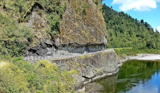
At the end of the gorge you will encounter a “T” intersection, turn right here to head to Westport. This section of road is very interesting with traffic lights controlling traffic around rock bluffs and the famous “Hawkes Crag”
The road narrows down to one lane and is like an open sided tunnel. It is narrow and tight but all vehicles will manage this section quite easily, just take your time and be careful.
Just before you get to this amazing rock you will see a Cafe/Bar at Berlins. There is plenty of history about the building of this section of highway to see as well as a great view over the river. There are plenty of food and beverage options and tons of safe parking on both sides of the road.
Hawkes Crag is just a few klm’s further towards Westport from the cafe.
Many visitors to the area under estimate the sights and activities North of Westport. We have visited this region only a few times, but intend to go back and dig deeper. There are a number of accommodation choices, but we recommend Karamea
You can base yourself here for a few days, weeks or months and really explore the region. Do not under estimate what you can see and do.
The northern part of the West Coast of the South Island is often overlooked by tourists, both international and national. The roads on the West Coast are some of the best in New Zealand. Wide sweeping bends, long straights and stunning sea and coastal views.
The northern most town is Karamea just 98 klm’s north of Westport. The road to Karamea from Westport starts in the main street with a right hand turn as signposted. It’s not a huge sign and could easily be missed.
The first 50 klm’s are easy sweeping bends and long straights, then you head up and over the Karamea Bluff which is 16 klm’s of tight corners and bends but the road is quite suitable for all vehicles. In the heat of summer the road seal melts and the road becomes very slippery, especially for motorbikes, so take care.
The northern Westcoast has a very rich history of mining and forestry. Approx 20 klm’s out of Westport towards Karamea is the Denniston mines ad there are great lookouts, historic sites and even a coal mine tour.
In my opinion as there is so much to see and do both paid and free, taking a week or more to explore the area is well worth it.
In time we will come back and explore much more of this region and write further about it. For now I will write about Karamea.
Karamea lies close to the coast and is a very flat and spread out village with a school, tennis courts, a DOC office, motels, hotel, backpackers, food store, garage, and a few other businesses. It is the first and last township for those walking the Heaphy Track which connects the West Coast with Golden Bay in the Tasman District.
I recommend that when staying you choose the Karamea Village Hotel. This place has a lot of historical information and the proprietors will ensure that you have a great stay. From the Hotel take the road that heads south (directly in front of the main entrance and turn left). This road will take you down to the Estuary River Walk. It takes less than 30 minutes to easily stroll around an easy track and at sunset is spectacular.
The beach at Karamea is NOT recommended for swimming as strong tidal rips are found here.
Heading north from Karamea you will find a large number of very interesting places to visit. You can drive to the start/end of the Heaphy track within 30 minutes easy drive.
There are a number of very interesting walks including the Oparara Arches which are simply stunning. To get there just drive north from Karamea approx 10-15 mins and look for the small sign on the left hand side of the road pointing right to the Oparara Arches. The drive in is 16 klm’s of windy, hilly and very rough gravel road. It is very narrow so drive very slowly and carefully and take your time. There are very few places to pass and definitely do NOT tow a caravan or take larger motorhomes in.
When you arrive at the first car park there are picnic tables, flush toilets and information boards on the walks and history of the region.
The walk to the Arches starts from here, just to the right of these buildings. It is a very easy walk with gentle up and downs suitable for most people (Not for wheelchairs).
Along the walk which takes around 10-15 minutes you will see some beautiful river rocks and streams.
The Arches are amazing, you will feel very small and totally forget that horrible road in. Take time to just sit and marvel.

Be very careful if there has been a lot of rain as rivers will rise very quickly.
Further up the road are caves, however the day we visited we didn’t have time to visit them, so I’ll write about those on my next visit.
It is free to visit the Arches and two of the caves, however there are guided tours available through another two caves for around $150 each.
South of Westport is a huge region of sights to visit and explore. If you don’t have time to check out the northern region of the West Coast, then just 6 klm’s before Westport, take the left turn towards Punakaiki and Greymouth. It is approx 100 klm’s south to Greymouth and you will pass through Punakaiki which is home to the Pancake Rocks and Blowholes.

However before you just take off southwards you can take a look at the Seal Colony at Cape Foulwind. You can get to this place by turning south towards Greymouth and then turn right approx 5-6 klm’s down the road, or proceed towards Westport and turn left at the next major intersection also 6 klm’s distance. If you go this way, you can come back out onto the main south road again after visiting Cape Foulwind. There is no charge to visit this area.
Allow a good couple of hours to explore, and longer if you like to sit and relax. There are cafes available close by, however if you are low on fuel, refill in Westport as it is 100 klm’s to the next available fuel stop.
The drive south on state highway 6 will give you some spectacular views of the West Coast coastline and bush clad mountain ranges. The road starts off quite straight with a few gentle curves and not much up and down. It is a great road for motorbikes, motor homes and caravans. The West Coast is renowned for its high rainfall especially over the winter months so plan your timing accordingly and check the weather forecasts.
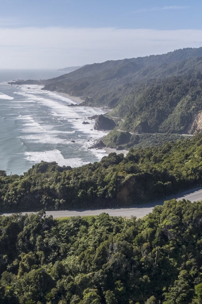
There are a number of tight sections of road, but the scenery outweighs the road conditions so much you’ll hardly even notice it. Motor bike riding in either direction on the main road the length of the West Coast are simply staggering on a clear fine day.
Arriving at Punakaiki you will see a variety of gift shops and cafes on the landward side and a series of stonewalls leading you into the Punakaiki walkway.
In 2013, the sea swell created the best views of the blowholes in action that I have ever seen. Getting to see the blowholes really going off is purely a chance situation, you just have to take what you get on the day. The day we arrived the swell was perfect, however within 20 minutes the swell had gone and with it the amazing display. However don’t be put off as this place is free to visit and is still amazing on any day.
It can take around an hour to really take a good long look and enjoy the views, sounds and smells. I prefer to walk around the track in a clockwise direction. There is a good display board at the entrance showing you the track layout.
If you have time, take a walk North and about halfway down the steep hill on the landward side you’ll see some timber steps which will lead you into a cave. It’s a great place to check out.
Leaving Punakaiki the next town is Greymouth, the largest town on the West Coast. It has most things that you will need. The Grey River runs into the sea and you can view the fishing boats navigating the bar which at times can be very entertaining if not downright frightening to watch.
Stock up in Greymouth if you are planning on taking a few days to travel south as grocery items will only get more expensive until you reach Invercargill or Dunedin.
Driving south you will shortly come across one of the few remaining rail/road shared bridges. There can at times be delays here as it is a one lane bridge. This bridge was replaced in 2019, probably good for the locals, but sad for those of us who loved the interaction between trains and road traffic.
Just south of here is the turn off to Arthur’s Pass towards Christchurch and the East Coast. This road is not recommended for towing large vehicles, but is a stunning drive right through some very beautiful country. However if you are heading to the Glaciers turn right at the round about and head towards Hokitika.
You will drive through farmland mostly but will have some great sea views. Hokitika is the West Coast’s second largest town or similar is size to West Port. Drive down to the town centre for some local crafts, restock or enjoy a coffee, beer or local cuisine. Just behind the main street is the beach, which is your typical rugged west Coast beach. Well worth checking out.
Driving south from Hokitika you will see a mixture of farmland and native bush. There are some great roads and scenery. Our advice is to miss stopping at the Salmon Farm you will see. We were really disappointed in the quality of this place.
There are a number of one lane bridges with typical rocky rivers flowing beneath. The views of the bush and mountain ranges are wonderful.
Franz Joseph and Fox Glaciers are within an easy drive south of Hokitika. Allow a couple of hours as you’ll want to stop and admire plenty of wonderful sights along the way. Both glacier towns have plenty to see, do and experience. There are walks, helicopter and plane flights, guided walks, restaurants, cafe’s, bars and so many other attractions that you could spend weeks here and not see or do them all.
Further south you drive towards the small town of Haast which is the start of the road over the Southern Alps known as the Haast Pass. Try to do this trip in good weather, so planning your journey is vital. Watch the weather reports and pick your days as there are so many visual attractions to check out. It is a great drive for all vehicles, cyclists will know they’ve had a workout riding this road. It is windy and steep in places and often in bad weather is closed due to slips or snow.
When you come out of the Haast Pass you enter into the high country of Otago. The road follows some beautiful lakes and the landscape changes to bare rock and tussock. The roads are great and the scenery spectacular. The first major town you come to is the resort town of Wanaka. Here is a variety of accommodation, food and activities all nestled beside Lake Wanaka. There are ski fields and boating, shopping, puzzle world and many other attractions.
From here you have two choices for travelling to Queenstown, the Vegas of the South Island. We have dedicated a separate page for Queenstown and the bottom of the south here.